You were told that maps don’t lie — that what’s printed on them is truth, a reflection of the world as it is. But there was once an island that existed for hundreds of years, appearing on official charts, trusted atlases, and schoolroom globes. Then, one day, it vanished. Not because it sank beneath the waves, but because someone finally realized it had never been there at all.
For centuries, mapmakers copied one another. Every new map was partly a work of art, partly a chain of inherited errors. Somewhere in that chain — perhaps around the early 14th century — a tiny patch of land appeared off the west coast of Ireland. It was called Hy-Brasil. Some spelled it O’Brasil, some just “Brasil,” but it wasn’t the country we know today. It was said to shimmer in the mist, visible only once every seven years. Fishermen spoke of seeing its shores on clear mornings, a dark line on the horizon that faded as they sailed closer.
The legend grew, and with each retelling, Hy-Brasil took on more detail. It became a place of lush hills and silver rivers, sometimes home to monks, sometimes to an ancient, advanced civilization. Some said it was a refuge for lost souls; others believed it was where knowledge itself was kept safe from the chaos of the mainland.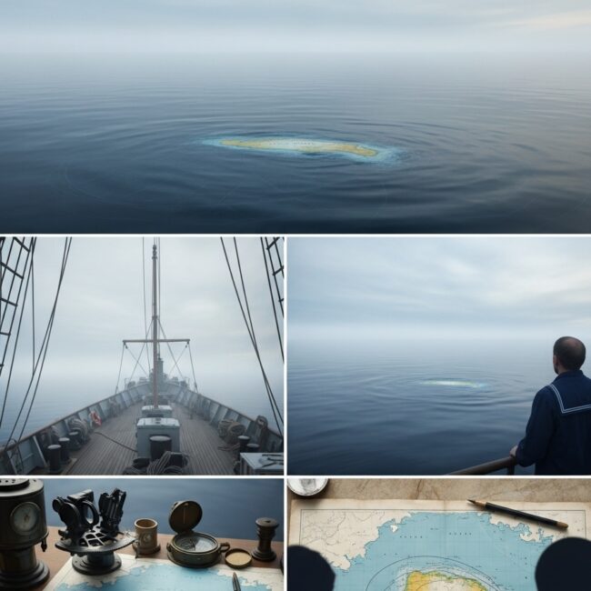
By the 1600s, explorers were sailing west from Galway and Cork, determined to find it. They returned with stories — islands glimpsed, shapes that vanished, coastlines that shifted like smoke. In 1674, a man named Captain John Nisbet claimed to have landed there. He said the island was inhabited by wise men who gifted him books of gold. His testimony was written down, circulated, believed.
And so, for another two centuries, Hy-Brasil remained firmly on the map. You could find it in atlases, sitting quietly between Ireland and Newfoundland, an island that cartographers accepted without question. It appeared in serious works of geography, right alongside real places. It even made its way into early navigation charts used by sailors crossing the Atlantic.
But something about the story didn’t add up. When Britain began its great mapping efforts in the 19th century, survey ships combed the Atlantic with precise instruments. They sailed the coordinates where Hy-Brasil was supposed to be. Nothing. No landmass. Not even a reef or sandbar. The ocean floor there was smooth and deep. Still, some captains insisted they’d seen it — a flicker of coastline, a shadow just above the horizon. Mirage, the scientists said. Atmospheric trickery. The mind’s tendency to fill in what it wants to see.
By the late 1800s, the island began to quietly vanish from new editions of maps. No announcement, no correction, no grand admission of error. It was simply erased. The next generation of schoolchildren grew up with atlases where the ocean lay undisturbed between Ireland and Canada.
And yet, the story didn’t die. Locals along Ireland’s west coast still tell of days when the fog clears and the outline of Hy-Brasil shimmers faintly in the distance — too perfect to be a cloud, too steady to be a trick of light. Some say it’s still there, hidden behind a curtain of mist, a place that reveals itself only to those who believe in it.
The truth, though, may be more complicated — and more human. Hy-Brasil wasn’t the only “phantom island.” Maps once showed dozens: St. Brendan’s Isle, Frisland, the Island of Demons. Each was a ripple of rumor passed through hands and ink, shaped by faith, pride, and the limits of what we could verify. Mapmakers didn’t want to admit uncertainty. They’d rather fill an empty space than leave a blank one.
And in a way, that’s what Hy-Brasil represents — not a failure of navigation, but a glimpse into how humans handle the unknown. We create stories to make sense of mystery. We turn fog into coastline, myth into geography. We believe, because the idea of something existing just beyond reach feels better than the idea of nothing at all.
Even today, satellites orbit the earth, scanning every inch of ocean, and Hy-Brasil isn’t there. Yet it lingers in the collective imagination — in books, in music, in local folklore. Some conspiracy-minded corners of the internet even suggest it’s hidden intentionally, that ancient knowledge sleeps beneath the Atlantic. Others see it as metaphor: a symbol of the world we keep trying to map but never quite understand.
If you stand on the cliffs of western Ireland at dusk, the sea stretching endlessly before you, it’s easy to see how the legend began. The horizon blurs, light bends strangely, and for a moment you might swear there’s land out there — faint, waiting, half-remembered. Maybe it’s just the brain’s way of reaching for meaning in the vast unknown. Or maybe it’s something older — a quiet echo of all the worlds we once believed in.
Maps, after all, are more than directions. They’re confessions of what we think exists. And when an island like Hy-Brasil disappears, it doesn’t just leave an empty space on paper — it leaves a question hanging in the air. What other truths have we charted so confidently, only to learn later they were drawn in fog?
If this story made you pause, don’t let it disappear again. Look it up. Read the records. The truth is there if you search for it.